Legal Descriptions

Why might you need a legal description
A legal description is used in official and legal contexts, such as:
- Property deeds (when ownership is transferred)
- Easements
- Acquiring right-of-way
- Quitclaiming property
- Lot line adjustments/parcel mergers
- Court cases involving land disputes
- Land surveys and zoning documents
Why it matters
Street addresses can be unclear or duplicated. A legal description:
- Uniquely identifies a property
- Defines exact boundaries (so there is no confusion about where the land starts and ends)
- Is legally binding in transactions and disputes
Common types of legal descriptions
1. Metes and bounds
- Uses directions and distances (e.g., “north 100 feet, then east 50 feet…”)
- Often used for irregularly shaped parcels
2. Lot and block (recorded plat)
- Refers to a subdivision map (e.g., “Lot 5, Block A of Sunnyvale Subdivision”)
- Common in residential neighborhoods
3. Public Land Survey System (PLSS) / rectangular survey system
- Uses townships, ranges, and sections
- Common in many U.S. states, especially rural areas
4. Strip/right-of-way descriptions
- Used for linear projects such as roads, utilities, pipelines, or easements
- Typically based on metes and bounds or PLSS references
Who prepares a legal description?
In California, legal descriptions are not restricted to a single profession. However, in practice, they are typically prepared by licensed professionals due to the precision and liability involved.
1. Licensed land surveyors
- Licensed by the California Board for Professional Engineers, Land Surveyors, and Geologists
- The most common and appropriate professionals for preparing or reviewing legal descriptions
- Responsible for determining and certifying property boundaries
2. Persons working under the supervision of a licensed land surveyor
- May assist in drafting descriptions
- Work to be performed under the direction of a licensed land surveyor
What is needed when preparing or requesting a legal description?
- Title report
- Vesting deed
- Recorded maps (subdivision or parcel maps)
- Assessor maps (supporting reference only)
Different parts of a legal description Exhibit “A.”
1. Preamble (introductory clause)
The preamble sets the stage by identifying the property’s general location.
What it includes:
- State, county (and sometimes city)
- Reference to a subdivision, tract, or survey system
- Parcel or assessor information (if applicable)
Example:
“Located in the County of Riverside, State of California, being a portion of Lot 5 of Sunny Acres Subdivision…”
Purpose:
- Identifies the general legal location
- Connects the parcel to public records
2. Body (descriptive portion)
The body is the most important part—it defines the exact boundaries of the property.
What it includes:
- Point of Beginning (POB) / True Point of Beginning (TPOB)
- Bearings (directions)
- Distances
- Curves (if applicable)
- Monuments or landmarks
- Calls (each step in the boundary description)
Example (metes and bounds):
“Commencing at an iron pipe; thence North 100 feet; thence East 50 feet…”
Example (lot and block):
“Lot 12, Block A…”
Purpose:
- Precisely defines the parcel boundaries
- Legally establishes the property limits
3. Closing clause (conclusion/qualifying language)
The closing clause wraps up the description and may include clarifying or limiting language.
What it includes:
- Return to Point of Beginning (POB) or True Point of Beginning
- References to recorded maps or documents
- Exceptions or reservations (e.g., easements)
- Qualifying phrases such as “more or less.”
Example:
“…to the True Point of Beginning.”
“…Excepting therefromthe following…”
“…The sidelines of said strip…”
Purpose:
- Confirms the description is complete
- Connects it to official records
- Identifies exclusions or limitations
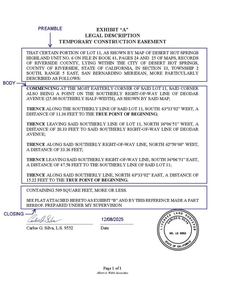
Simple way to remember
- Preamble = Where is it generally?
- Body = What are the exact boundaries?
- Closing= How is it finalized or qualified?
Exhibit “B” (also common)
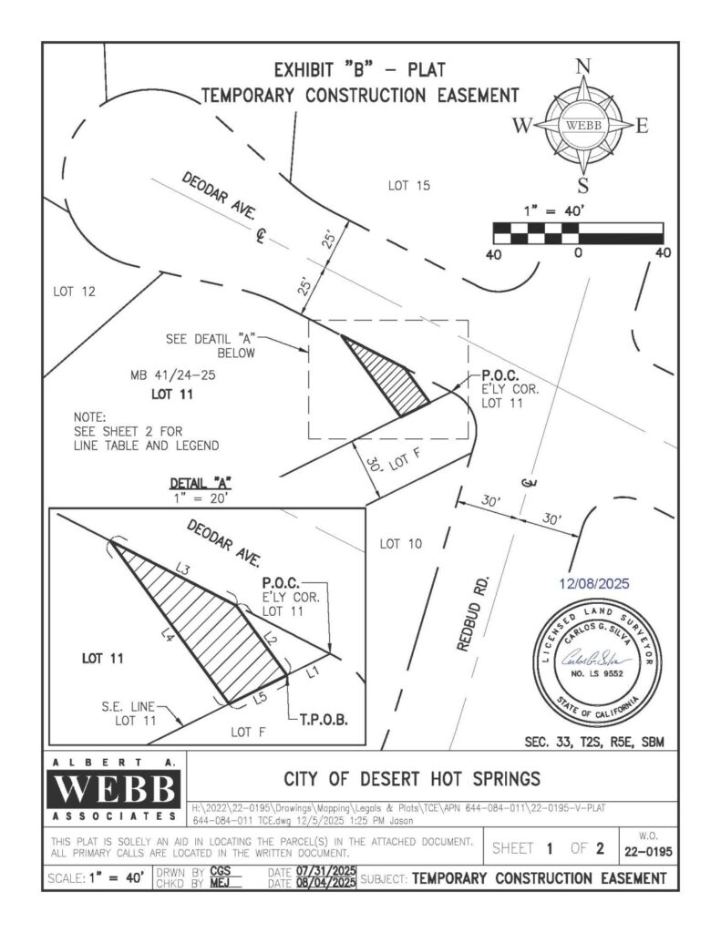
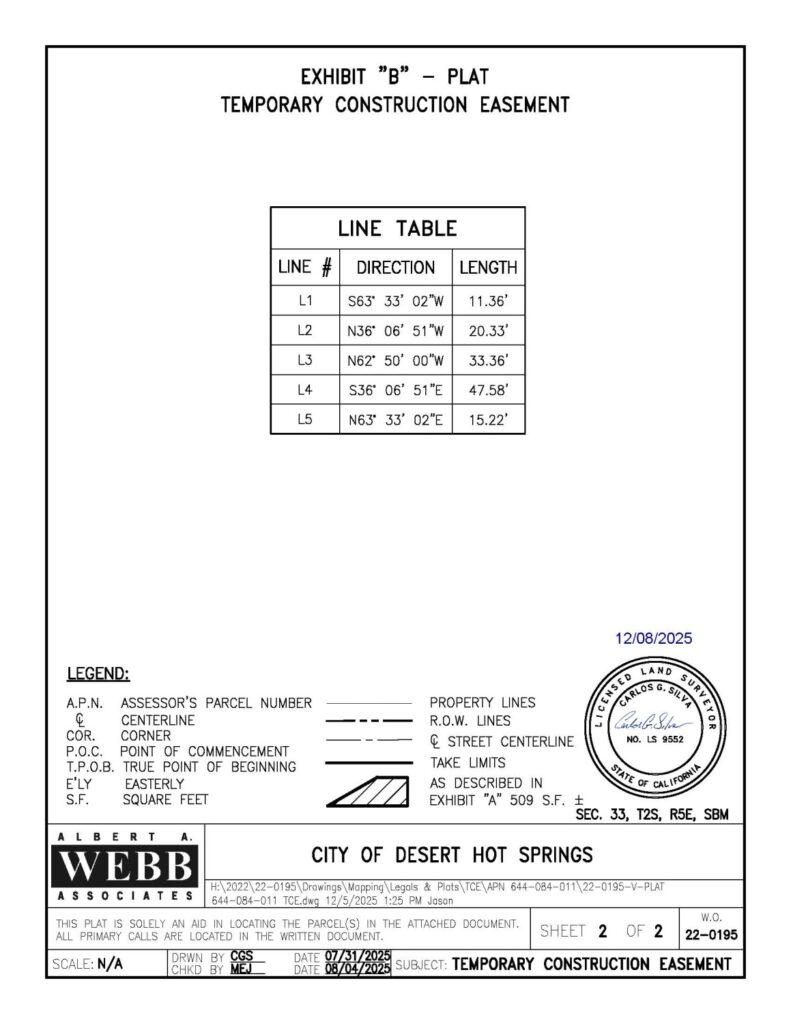
- A recorded subdivision map or sketch, we typically refer to this as a “plat.”
- Shows boundaries visually
- Often labeled “Exhibit B” in easements or development agreements